Kara (Kozah)
Kara is a city in northern Togo, situated in Kara Region, 413 km north of the capital Lomé. Kara is the capital of the Kara region and, according to the 2010 census, had a population of 94,878. The Kara River flows through the city and is its main resource of water. The city developed from the 1970s onwards from the village originally known as Lama-Kara. Its growth was largely due to the influence of the previous Togolese head of state Gnassingbé Eyadéma who was born in the nearby village of Pya and understood Kara's strategic position at a crossroads of two trade routes.
In 1902, a bridge over the Kara River was built by the Germans, which marks the beginning of the city. Under the presidency of Gnassingbé Eyadéma, in the 1970s, the city developed particularly because of its role in holding political events.
In 1902, a bridge over the Kara River was built by the Germans, which marks the beginning of the city. Under the presidency of Gnassingbé Eyadéma, in the 1970s, the city developed particularly because of its role in holding political events.
Map - Kara (Kozah)
Map


Country - Togo
 |
 |
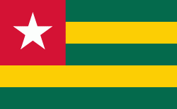
| Flag of Togo | |
Various people groups settled the boundaries of present day Togo between the 11th to 16th centuries. Between the 16th and 18th centuries, the coastal region served primarily as a European slave trading outpost, earning Togo and the surrounding region the name "The Slave Coast". In 1884, Germany declared a region including a protectorate called Togoland. After World War I, rule over Togo was transferred to France. Togo gained its independence from France in 1960. In 1967, Gnassingbé Eyadéma led a successful military coup d'état, after which he became president of an anti-communist, single-party state. In 1993, Eyadéma faced multiparty elections marred by irregularities, and won the presidency three times. At the time of his death, Eyadéma was the "longest-serving leader in modern African history", having been president for 38 years. In 2005, his son Faure Gnassingbé was elected president.
Currency / Language
| ISO | Currency | Symbol | Significant figures |
|---|---|---|---|
| XOF | West African CFA franc | Fr | 0 |
| ISO | Language |
|---|---|
| EE | Ewe language |
| FR | French language |
| HA | Hausa language |